Friday, July 18, 2014

NT cattle stations and their campgrounds


We’ve done it! We’ve driven more than 800km on the Donohue and Plenty Highways, from Boulia to Alice Springs.

The Burke River at Boulia, just a series of waterholes at
this time of year.
And actually, it was not as bad as we had expected. We’d heard some good reports of these two roads, one from Boulia to the NT border, and the other further west to the junction with the main north-south Stuart Highway.

Those reports turned out to be correct, with more bitumen than we had expected on the Donohue, and the Plenty did not have many bad spots. Some sections were well-gravelled and smooth, and some were full of red bulldust and corrugations, so a sturdy vehicle was certainly needed.


A glorious outback sunset at Boulia.


We took our time, staying at campgrounds at two stations. One was Tobermorey, just over the NT border. It was grassy and well-watered and apart from the station generator running until 10pm, a haven of peace. The next was at Jervois Station, further into the NT. Its campground was just a dusty area away a little from the homestead, but it had a scattering of trees, was right beside the very dry riverbed, and had barbecues but campers needed their own firewood. Close to the homestead is the heritage-listed rocket shelter erected by the Woomera Rocket Range in the late 1960s.


Along the Donohue Highway, near a station entrance.
As it was letting off rockets flying towards Central Australia, Woomera built 19 of these shelters and installed radio telephones to let the station families know when a rocket was to be launched, so they could seek shelter in case in came down on their homestead. There was unconfirmed reports that rather than seeking shelter, families used to stand on the earth roofs of the shelters to watch the rockets. When we bought diesel at Jervois it was $2.30 a litre.


John with the biggest termite mound along
the Plenty Highway.
We had intended going on to another campground called Gem Tree, closer to the junction with the Stuart Highway, but at Jervois got talking to the couple who publish the campers and caravanners ‘bible’, Camps 6 or 7. They had been in WA and the NT researching Camps 8 and told us they’d the day before visited a remote and beautiful campground 75km north of the Plenty Highway.

So we turned off where they had told us and drove to a property called Mt Swan, which runs a  store, mostly for the surrounding Aboriginal communities, as well as an art gallery showing their work. This includes artists from the neighbouring Utopia community so there was some wonderful stuff there . . . and fairly pricey, as they’re pretty famous.

The German and Italian backpackers running the store, and the Polish girl who showed us round the makeshift gallery in former stockmen’s quarters all said the Tower Rock campground was worth visiting, so on we jolted for another 27km over fairly bad dirt roads.


The graves of Mac and Rose Chalmers under Tower Rock.
It was glorious! It was the favourite picnic ground for the Chalmers family, who had settled a station property there in the 1920s, and whose family still own the area. A second-generation Chalmers, who became a top cattleman and advocate for the area's Aborigines, and his wife are buried there in the 474ha reserve given to the NT Govt by the current Chalmers owner in 2011.

We clambered to the top of the rock pile dominating the landscape, taking photos of the limitless landscape, with our motorhome just a dot in the foreground. Nobody else  
came there and it was just us, the stars, and a cold, windy night.

Look closely and you can just see the 6.5tonne Isuzu motorhome.

‘Facilities’ are just two hessian-curtained loos. They could be called Mobil-loos as they are long-drop pits, with Mobil fuel drums wedged in to hold toilet seats. When we called back at the store to buy some bread, Sonya Chalmers, wife of the owner and operator of the gallery, assured us she was hoping to improve them as soon as possible.


One of the loos at Tower Rock.
Basic, but it works.
It was a unique experience and I’m so pleased we ran into the Camps people. They also gave us some helpful hints for places to stay in the Kimberley region as well as north of Tennant Creek.
With just a coffee stop at Gem Tree (a caravan park close to a major fossicking area), we arrived in Alice Springs in the early afternoon, as the dirt road had ended just more than 70km from the junction with the Stuart Highway.

That of course is a major road, with white lines in the centre, something we haven’t seen for weeks. There’s a rather strange structure just north of the town, marking the Tropic of Capricorn. We’d passed it, going north, between Bedourie and Boulia, and here we were, going south through it again.

We’re in a caravan park at the southern end of town, with the gap in the McDonnell Ranges looming above, and will dine at the park’s tavern tonight, do some washing and check the vehicle tomorrow, stock up at the supermarket, then take off on the Tanami Track on Sunday.

Next stop . . . Hall’s Creek in the Kimberley, then the Bungle Bungles.

Sunday, July 13, 2014

Oil, dinosaurs and camels

The small refinery at Eromanga

It’s not many times that one can sleep in a caravan park just across the road from an oil refinery, but that’s what we did in Eromanga. We had discovered back in 2012 what a thriving oil centre Eromanga was  . . . and its refinery has its own fuel pumps outside the perimeter fence, selling diesel and unleaded fuel many many cents cheaper than in the nearest town of Quilpie.

We had a delightful night there, exploring the village that afternoon, including an excellent living history centre, with the key available at the local pub, a great old stone building dating from the late 19th century. Eromanga’s other claim to fame are the dinosaur fossils relatively recently unearthed on a nearby station property. They are deemed to have been the biggest that roamed Australia, and have been called titanosaurus.


In the bed of Cooper's Creek
Then on we went towards Windorah, spending two nights camped at Cooper’s Creek. It was not running as well as when we visited in 2012 so there were not as many waterbirds present, but there were a few pelicans finding small fish. We had a unique experience there, with the 50-ish couple camped just along the creek bed inviting us to share their campfire after dinner.

It was all very pleasant and we all enjoyed a few drinks . . . then while John and her husband were engrossed in some technical discussion about electric appliances (he’s a retired electrician), she confided that they were ‘swingers’ and wondered if we were interested.

I gracefully backed off and she took no offence but told me all about their activities with a swingers’ club in Brisbane. This all happened at night and we had only seen them by firelight. When they pottered over to say goodbye the next morning, they were definitely not the image of sexy, attractive people pursuing a swinging lifestyle, having sex with multiple partners. They were frankly, quite unattractive and we could hardly keep a straight face. Ever since, John has referred to them as the ‘chandeliers’, as in ‘swinging from the chandeliers’.

Back to our journey . . . After looking around Windorah, and fuelling up, we headed west again towards Bedourie, where we found a delightful nook among some trees at the local racecourse, where camping was offered in conjunction with the local camel races.
Don Anesbury walking his camels around the track.

As we were a few days early, there were not many campers, and we met a couple from near Port Augusta, who had brought their string of camels to compete in those races, and then would go on to meetings at Boulia and Winton. They were great folk and we were so pleased for them when their camels not only won the Cup, but also the Plate. Their winning jockey was a young Irish bloke who has been working at Scone and first rode for them at a Forbes camel meeting. He also was fleet of foot, winning the men’s footrace.

The day also featured woodchops (nothing like those at the big shows), using hard blue gum logs from Emerald, the ringers and station managers put their backs into chopping those logs, with one of the most energetic the offduty policeman from Bedourie. One of his colleagues, from Mt Isa, won the men’s camp oven throwing contest later in the day.


A racing camel in full flight is
not a pretty sight


As Bedourie is the home of the Bedourie camp oven, there was also a damper cook-off, with 30  

Judging the dampers was a serious business
competing in three heats, and a gaggle of local blokes did the judging, tapping, breaking open and tasting the dampers, which were simply numbered. All ages took part, and would you believe the best damper was cooked by a nine-year-old boy, who took the first prize of $700, while a girl around the same age won the $300 second prize.


Men and women threw camp ovens, even the women took part in the woodchops, there was an hilarious event for the many kids where they had to chase and catch a six-week-old pig, who dashed all over the grounds, and an even more hilarious auction where people were bidding up to $80 for pink beanie with CAT (for Caterpillar) on it.

We had a ball.  Everyone else did too, including the travelling people in dozens of caravans, camper trailers and motorhomes who attended. The locals settled in for a big night of music and dancing but after we’d bought an evening meal from the catering area (volunteers under the instruction of the caterer, known to all as Dogger), we retired to the motorhome and our third night of a huge campfire, using some of the piles of wood dozed up around the grounds.


The land of the great plains and channels south of Boulia.

On we drove the next day to Boulia, stopping to make coffee at a tremendous lookout atop one of the few hills in those great western plains. There was a freezing wind blowing so we didn’t linger but there was a 360 degree view of the area south of Boulia, on a property known as Marion Downs.

Rain seemed to threaten but no moisture fell. That night, camped at the Boulia Caravan Park we got talking to an Aboriginal man who had pulled into a cabin next door with his grandson. He had just driven for 12 hours from Alice Springs along the road we’ll take in a day or two and reported some parts were a bit slushy after rain but predicted the wind would dry it off.

He’s an interesting character as he’s going to Birdsville for a meeting of his family group, which has shared management of a big area around the SA-NT-Qld borders with the various State governments, National Parks, etc. His sisters are driving up from Adelaide, through Marree, accompanied by the lawyers.

We need to stock up on groceries and essentials of life such as paper towels, chocolate and wine . . . as well as spuds and onion and some steaks . . . before we leave on Tuesday, calling at a station just outside Boulia to see the widow of a cousin of mine. Then it will be the Donohue Highway to the NT border, then the Plenty Highway from the border to the main north-south Stuart Highway from SA to Darwin. Not that the first two are sealed roads, despite being termed highways, so we expect to take a few days, not like the bloke next door who did it in 12 hours. Next stop, Alice Springs.


Thursday, July 10, 2014

From Fred Hollows to fossils


This post has been a long time coming, as we moved out of internet reception soon after Bourke. Sorry about that.


During our couple of wonderful days in Bourke, John finally achieved an ambition that had eluded him on two previous visits to the town: He visited the grave of Fred Hollows.
Fred's grave.


The famous eye doctor had expressed a wish to be buried in the town, a special place for him for that was where he first became aware of the appalling eye health of Aboriginal people and he meant a lot to the people of the district.

Although a lot of the historic cemetery is fairly parched, Fred’s grave lies under some coolabah trees, topped with a huge polished granite boulder, with a wonderful carved sandstone sculpture nearby. The whole area is surrounded by rocks in the shape of an eye and there is an evocative storyboard from the Fred Hollows Foundation, telling his story.

We also spent quite a long time at the Back O’Bourke exhibition in the fairly new tourist information centre, a series of linked pavilions set in grounds dotted with indigenous trees. As well as an outback show featuring horses and camels, and a splendid restaurant with a large outside area, the centre has this audio-visual exhibition explaining just what ‘Back O’Bourke’ really means.

People such as Henry Lawson and C.E.W Bean are quoted and there are masses of historical photos. It has all been done enormously well.

We topped off one exploring day with a trip on the PV (paddle vessel) Jandra for an hour on the Darling River, passing under the old bridge erected in the 1880s, from segments manufactured in


England and brought to Bourke in pieces aboard one of the many paddle steamers that plied the Darling. The Jandra was made locally as a replica of the original Paddle Steamer (PS) Jandra. But the paddle wheels (now electrically operated) and the whistle came from the PS Nile, a sister ship of the original Jandra.


A highlight of that cruise was the huge old river redgums that line the river, certainly one of the great survivors of the Australian landscape.

The Cunnamulla Fella
Eulo's diprotodon
When we left Bourke we headed north across the Queensland border, passing through the hamlet of Enngonia (that had its annual race meeting that day, but at 10am showed no sign of any such festivities). After stocking up on a few things at a Cunnamulla supermarket, just before it closed at noon, we went west to Eulo, where we spent the night in the grounds of the Eulo Queen Hotel, next to a huge old pepper tree. The village is home to the world lizard-racing titles held each August, and also has a bronze replica of a diprotodon at the eastern end of the main street. It’s the ancestor of the wombat and koala and was among important fossils found nearby as recently as 2011.

That country pub is full of character and has information about the woman known as the Eulo Queen, who ran a pub there in the late 1800s and wore a good deal of opal jewellery from the nearby opal fields.

Off we went to Thargomindah on Sunday, July 6, stopping briefly at its supermarket to buy more instant coffee, in case we ran out in less civilised areas. Would you believe that a 100g bottle of Nescafe Gold was more than $12? We also checked out the meat cabinet, in case we wanted to add to our stock in the freezer. Not bloomin’ likely, with a medium-size leg of pork $54 and a tray of four lamb loin chops $29! So the coffee, some sliced cheese and six bread rolls cost about $24.


The French and British flags
fly beside the Australian one
That little town, population 250, was the third place in the world to have street lights lit by hydro electric power in the 1890s, just one day after Paris and some time after London (see pic).. Those cities presumably used water from the Seine and the Thames, but Thargo (as the locals call it) used artesian water, coming out of the ground at 84C in a great pressurised plume.

The system then switched to diesel, especially after householders also wanted electricity in the 1950s, and now is on the national grid. There’s a replica of the old hydro artesian plant, and they let go some water every afternoon, but we were there in the morning so didn’t see it.

The road west from Thargomindah
The road just kept going west, a thin strip of bitumen going on and on, with John moving the motorhome off it for road trains coming towards us, laden with cattle. Eventually we reached Noccundra, where there is a pub and not much else. Lots of people in campervans, camper trailers and caravans were camping on the banks of the river, where there’s quite a lot of water.

A youngish couple from Adelaide next to us in a camper trailer had driven along the Birdsville Track, then to Innamincka, and planned to visit Cameron’s Corner before returning to Adelaide to work.


Thursday, July 03, 2014

Rocks, Greek cafes and plunging temperatures


The glorious old Deepwater Railway station.
We left the balmy coastal climes behind as we headed west from Lismore on June 30. It was rather nippy when we reached Tenterfield, and by the time we stopped at Deepwater for lunch (between Tenterfield and Glen Innes), John was forced to change his cargo shorts for jeans, don even more vests and jackets and put on his ugg boots.

It was 11 C, so our phones told us, and blowing a 35km/h WSW wind. Freezing!

We pulled off the highway to the old Deepwater Railway Station, long unused, but restored with a Bicentennial grant and looking quite smart, apart from the grass growing between the rails next to the platform.

Once we turned west at Glen Innes, we knew we were in for some cold, bright weather. West of Inverell we stopped at Cranky Rock Recreation Reserve, just east of Warialda. It was a glorious bit of bush camping, beside the Cranky Rock jumble of huge rocks and a creek, with a caretaker and only
Just some of the jumbled rocks at Cranky Rock.


about 4 other campers there.  It was about 4C the next morning but our diesel heater took care of that.


We followed the short walking trail to the top of the rocks on the next day, enjoyed the emus and kangaroos who wandered into the camping area, along with four tame peacocks and a flock of king parrots that came every afternoon to be fed at the caretaker’s cottage. We had a glorious campfire on the second night, and when I peeked out the window around 2am it was still glowing red.
 

Emus strolled around Cranky Rock reserve.

On July 2, we woke to 5C inside so it was probably about 2C outside. We set off for Warialda where we restocked some groceries, then headed south to Bingara. On the way we detoured east to the Myall Creek Massacre Memorial.

This is such a sad place, where 28 Aboriginal women, children and old men were massacred by a raiding party of stockmen and a squatter in 1888. But a local landowners and various others insisted that justice be done and seven men were eventually tried and hanged for the crime.


Bingara itself was a delight. We joined a party being taken on a tour of the huge old Roxy Theatre. It was built in 1936 as a art deco cinema by three Greek immigrants who also had the cafe next door and opened a guesthouse behind. They thought the people from the district would come into town to see a movie, stay the night, and need dinner and breakfast.


Our guide at the Roxy Theatre, with the set for a play about
to be performed .
This all worked well until around 1958 when cinema started dying, but the Gwydir Council has managed to get around $1.5 million in grants to restore the theatre, now used once again as a cinema, as well as a performance space (there was a set for a play in situ when we visited); as well as the Greek cafe next door, with booths and freestanding furniture built to match what would have been there in the 1930s. The terrazzo floor is original, as well as one set of furniture. There’s also a museum commemorating the role Greek-run cafes played in Australian history.

Before we reached Narrabri for the night, we visited some landscape etched out of glacial rocks, and then hiked about 1km from the highway to see Sawn Rocks, a fabulous natural volcanic arrangement.


Sawn Rocks
We spent the night at the Narrabri Showgrounds and were fascinated to see dozens of matching tents, slowly being disassembled. The caretaker told us there had been 80 there for a Keith Urban concert the previous weekend and they were now being taken away.

We made it to Bourke the next afternoon, after lunch by the Barwon River at Brewarrina . . . pelicans and whistling kites let us know it was the outback. From Narrabri to Bourke, and particularly around Wee Waa and Burren Junction, there were cotton bolls by the side of the road, where they had fallen from the big trucks carting recently-harvested cotton for processing. It is broadacre farming on an enormous scale, with the ploughed paddocks stretching to the horizon and beyond, and huge dams irrigating it all.

Flocks of emus were the major wildlife we saw in the latter stages of that drive to Bourke, and after the cotton petered out, it was back to sheep and cattle.

More about what we do in Bourke in the next post.

Sunday, June 29, 2014

We're hitting the road again


Here we go again.  We’re off tomorrow, June 30, on a four-month journey to the Kimberley region as well as Darwin and the Top End. We’ll travel west to Bourke, then north to Cunnamulla and even further north to friends/family in the Boulia area of western Queensland. Then we’ll head west along the Donohue and then Plenty highways to Alice Springs.

Just a little north of the Alice we’ll go north-west across the Tanami Desert to the Kimberley region.
John looking relaxed on the eve of our big trip.

We’re looking forward to it enormously as we haven’t done a long trip like this since summer 2012-13 when we went to Tasmania.

We’ve had plenty of short adventures in that time  . . . and only moved into our new house at Richmond Hill, on Lismore’s outskirts  a month ago . . . so we’re delighted to be getting on the road again in our faithful Isuzu.

I can’t guarantee how often I’ll do this blog, but at least once a week we’ll share with you our wanderings and what we’ve seen.

Join us!

Friday, February 08, 2013

Last post from Tasmania

Sadly, this will be the last blogpost from Tasmania. We are now back in Smithton, saying hello/goodbye to the family, before moving on to Devonport where we’ll spend Sunday night, leaving at 9 the next morning on the day ferry back to Melbourne.
The adventure does not end there, though, as we plan to return to the Central Coast via the high country of Victoria and NSW.
We have met some very interesting people in the past week. At Strahan, we noticed that the youngish man in the hired camper next to us was walking stiffly, and on asking what he’d done to his legs, found out he had run, yes RUN, the 82km Overland Track from Cradle Mountain to Lake St Clair the previous day. Normally it takes at least 3 days of walking, and more if the walker does some side trips.

The two intrepid walkers halfway around Dove Lake.

This Nowra plumber does such bush marathons as a hobby. He finished the 82km in a bit over 9 hours, coming in 5th in the race, won by a chap who did it in 8 hours.
Then, when we reached Cradle Mountain, where we donned our own walking boots and took our time (about 2.5 hrs) to do the 6.5km circuit of Dove Lake, our neighbours in the campground were a young Hong Kong couple in a hired motorhome.
They’d come to Australia for their honeymoon. She had studied at the University of Qld and he had studied in Canada, and they had 10 days of wandering Tasmania to complete.
After Cradle Mountain, we really went bush, driving a back road to the west coast which goes along the top of the Reece Dam wall. Wonderful engineering, once again.
We took the little punt . . . and the truck just about filled the whole space, and was just under the length and weight allowed . . . across the Pieman River at Corinna, which we’d visited 2 years ago in a hire car. That time we stayed in one of the refurbished miner’s cottages . . . it had been a mining settlement in the 1800s . . . but this time we had a campsite.
The old huon pine launch that goes from Corinna
to the mouth of the Pieman River. On the opposite
bank is the southern road approach to the punt.
We had a great meal at the pub, which is the centre of activity for the whole place, and at night, everything was wonderfully quiet, with no street lights.
The next night was even quieter, and totally black, as we went north on the dirt road called the Western Explorer, through melaleuca forests and then wonderful buttongrasss uplands, with the white quartzite gravel road winding on and on over the hills for about 70km, then dived into the Tarkine forests to stay at a Forestry picnic and camping area called Julius River.
It’s more of a rivulet and it ran just behind our campspot. It was a beautiful little glade, and we found the nearby rainforest walk utterly delightful, with fabulous huge old trees.

A poppy crop, near Smithton, with the pods ready for
 harvesting. Tasmania provides about half the world's
requirements of medicinal opiates, suich as morphine
 and codeine..

To our special delight, along the road to this place, we spotted a young Tasmanian devil wandering on the road. He soon hightailed it into the scrub when he heard our engine, but that was the first one we’d seen. Later we saw a tiger snake (mostly black with subtle green striped belly) going about his business.
When we left Julius River this morning we wandered the forest roads for quite a time, even taking one that had foliage getting closer and closer on each side . . . and then suddenly we were out in farmland again and before long we were entering Smithton.
We have duly admired the cubbyhouse that John helped Nigel build before we left after Christmas. It is now completed, painted and decorated with all Erin’s favourite things, and we had afternoon tea with her on its verandah when she came home from school.
Thanks for staying with us during our two months in Tasmania. We have loved every moment and are quite sad to be going back to ‘the north island’, as the Tasmanians call it.

Sunday, February 03, 2013

Wild about the West Coast

So here we are in Strahan, on the beautiful west coast of Tasmania. West Coasters, who have a very dry wit, say it only rains twice a year in these parts . . . once for five months, and once for seven months.
In Queenstown, up in the mountains behind this harbour, they say it rains for nine months of the year . . . and it’s wet for the other three!
We came here across Tasmania, from the hop fields near New Norfolk, the trout and salmon hatchery at Plenty, and the last of the raspberries, through the great forests and lakes and close to some highly impressive hydro-electric power stations.

The historic salmon ponds at Plenty in a gorgeous
park setting.

While near New Norfolk, I had success in finding the grave of a First Fleet convict ancestor of a friend in NSW. I’d done some research which showed that this man, William Edmunds, was one of 4 Welshmen in the First Fleet, and that he was buried at a ‘Methodist chapel at Lawitta, near New Norfolk’. We found that plain little chapel on a country road, next to an orchard, with a lot of gravestones so old their inscriptions were obliterated. One had been fairly newly marked as that of Betty King, the first white woman to set foot on Australia (she was first off her convict boat).
I took photos of the whole place but was disappointed I couldn’t find the grave. We decided to visit the orchard to see if it had any fruit for sale, which it did, and the owners were incredibly helpful when I mentioned what I had been doing.
The wife dug out local histories and records of graves, the husband even phoned a neighbour who knew a lot about the First Fleeters buried around there, and we left with cherries and the last of the apricots as well as new info, showing that Edmunds was buried in New Norfolk itself. This was quite true, and we found the old cemetery where he’d been laid to rest, aged 92, in 1843. Once again, the old gravestones could not be read, and they’d been lined up against a side fence, but a new memorial listed all those buried there, including him.
On we went then, into the mountains, side-tracking at one stage for lunch and discovering some of the recently-burnt areas in those central highlands. We spent the night at a former hydro village, Tarraleah, built for one of the early schemes in the 1930s, so all the buildings are beautiful art deco style. Some of the later such villages, built in the 1950s, are pretty ordinary.

The water from the River Derwent going down
to the Tarraleah power station. It goes
through eight such stations, and then
becomes Hobart's drinking water.

The whole of Tarraleah was bought by a private company in 2005 and operates as a tourist resort, with people able to book one of the houses, or stay in a small caravan park. There’s an excellent pub, where we ate that night, and it was crowded with young men and women, Hydro employees who were visiting for some work on one of the two massive power stations at the bottom of the valley.
Our next night, after only a short drive, was Lake St Clair, with a detour to see the Wall in the Wilderness, a private project by a sculptor, who is creating a huge huon pine wall showing scenes from the region’s past. It’s highly impressive, in a wonderful timber building which houses it, and a gallery all around of his other works.
We had a lazy day at Lake St Clair, as the weather was fairly frightful. We felt for all the earnest walkers getting on the ferry to be taken to the northern end of the lake to start the Overland trek to Cradle Mountain. It also collects those who’ve done the six-day trek and brings them back to the excellent visitor centre. We had planned to go on the ferry, but frankly, in bad weather one wet lake’s surrounds are like lots of others.
That evening, as we sat outside the motorhome in a lovely bush setting, along came first a totally unafraid currawong to wander around the ground, then an echidna, later a wallaby, and just as were going to bed, we heard something outside, and there was a brush possum investigating our chairs.

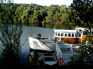
Our cruise boat off Sarah Island, former convict station
in Macquarie Harbour.

The next morning, as we headed further west, we saw a wombat on the side of the road. The only other live one I’d seen on this trip had been at night at Petal Point, so I leapt out in the rain to photograph it . . . just as he turned and trundled off into the buttongrass plain.
Since arriving in Strahan we’ve had two wonderful excursions, one a cruise on Macquarie Harbour and up the Gordon River; the other the West Coast Wilderness Railway from Strahan to Queenstown.
We had taken the premium package for each, so it was bubbly all the way, and a hostess to cater to every need whether in the upper cabin of the big catamaran, or the beautifully-timbered railway carriages.

The interior of our carriage, with the steam engine in front.

We left Strahan in a train pulled by a diesel loco, but then changed halfway to a 117-year-old steam loco fitted with the special pinion wheels to haul us up the rack railway system which had been the only way to conquer a 250-metre hill on the original railway, which brought ore from Queenstown down to Strahan for shipping. After reaching Queenstown we returned by bus, making it a full day out.