Monday, January 28, 2013

Magical day in the wilderness


Beautiful Lake Pedder.

From strolling through one of Australia’s oldest botanic gardens, to flying in a light aircraft to Tasmania’s south-west wilderness, and now settled into a National Park campground east of Lake Pedder and Lake Gordon. . . we’ve had a wonderful few days.
It DID rain for our lunch with John’s old friend at the Royal Tasmanian Botanic Gardens, but it cleared away as we ate at The Gardens restaurant, and we were able to prowl around later, enjoying the ambience of the gardens, established in 1818.
Interestingly, Marcus (John’s friend and former bonsai teacher) told us that while a good deal of the garden’s infrastructure had been built by convicts, in fact it has had a continuous labour force of convicts and still has day-release prisoners from near Hobart who work in it.
We had based ourselves at the Hobart Showgrounds motorhome park, still not completely equipped with power and water supplies as any normal caravan park, and it became a bit of a circus when people starting arriving from all over for the annual Horse of the Year event over the Australia Day weekend.
Not only did they have horse floats from which the prized horses stepped into stables, some had massive trucks with horse accommodation at the rear and small motorhome arrangements just behind the cab, so they were parked all around us. The most innovative was a former horse float which had been completely turned into living quarters for a mother and her 2 daughters.
We left all the horsey folk behind on the Sunday when we had a flight from Hobart to Melaleuca organized. We’d seen walkers staggering into campgrounds at Cockle Creek when we were there, having taken 7 days to do the South Coast Walk. We became fascinated by the area, and bought a book about it. The walkers are flown to Melaleuca, then walk out, and in reading that detail we found the same light aircraft company also did day trips, including walking around that area and a boat trip on the nearby Bathurst Harbour.
So . . . off we flew, with two other couples, for a magical day.  A man called Deny King had mined tin in the Melaleuca area for years and he had laboriously built the airstrip among the button grass plains. His house is still there and family members come down for a month once a year to try to keep it all together, but the whole area is now a national park.

The boat in which we toured the waterways, beached
 where we had lunch.

Our pilot wore several hats, as a tour guide and also qualified coxswain, as it was he who took us out in a small boat to tour the creek and inlet that lead to the harbour and eventually out to sea. He had promised us lunch and we thought it would just be a sandwich in the boat, but he took us to a glorious little beach, set up a table with salads, smoked salmon, cheeses and bottles of some of Tasmania’s best wines. When we returned to the airstrip area we were taken to a bird hide where we were lucky enough to see one of the orange-bellied parrots, highly endangered, that summer in the area. It is hoped numbers will increase and there’s much excitement about some fledglings recently spotted.

The airstrip at Melaleuca, with paths through the
peatland visible.
 So home we flew in the late afternoon, this time across the island rather than around its south coast, so we were rubbing shoulders with great peaks and looking down at some of the tarns, little lakes high in the mountains.
Today we saw much bigger lakes near Strathgordon, Lake Pedder and Lake Gordon. The engineering that built the fabulous Gordon Dam curved wall is amazing, as is the underground power station that uses the water from the linked dams to generate 13% of Tasmania’s electricity.

The worker's cable car hovers before
plunging into the gorge in front of the
dam.
 While we were gaping at the Gordon Dam wall, an employee started descending the outside of it in a cable car, which seemed to hover on a curve, then plunged straight down! We didn’t wait around long enough to see him come up again but felt lucky to have even seen that dramatic plunge.
The mountains are splendid and photographs just do not do them justice, but we kept stopping to try.
By late afternoon we had left the lakes and mountains behind and were in the Mt Field National Park campground, among gloriously tall straight trees, feasting on the raspberries, blackberries and cherries that we’d bought along the way this morning.
Sadly, the raspberries seem to be almost finished; the apricots are down to their last few weeks, as are the cherries; but the blackberries are just starting. The ones we bought today were cultivated in an orchard, but the roadsides are full of rapidly ripening blackberries on fences, though avoiding the thorns could be a problem.
Now we have a couple of days to enjoy the way west on the Lyell Highway at leisure, as we’re due in Strahan on Thursday for more excursions by boat and train.


Thursday, January 24, 2013

World's end at Boltons Green

We’ve done it! We have driven as far south in Australia as one can, to Recherche Bay which the French explorer Rear-Admiral Bruny D’Entrecasteaux described as ‘a lonely harbour at the world’s end’.

The lifesize sculpture of a 3-month-old southern right
whale, which used to be hunted in Recherche Bay,
 There are several camping areas on the bay and we spent a night at the southernmost, Boltons Green, with just some National Park-serviced pit toilets and one tap supplying rainwater. There were lots of campers, obviously enjoying the fishing in the bay, and even a family of walkers who arrived in the long twilight, great packs on their backs, and we suspect they’d done the 7-day walk along the southern coast.
After that we headed north again and had a wonderful few hours creaking along through the bush on the Ida Bay Railway, just south of Southport. It’s a former tramway that used to take limestone to be loaded on ships for use in making acetylene.
The open carriages can be a bit brisk if the wind is blowing, but the little loco doesn’t get much above walking pace and the driver, a diminutive chap called Tony, was full of information about the people who used to live in that area.

John and Tony, the petrol loco driver for the Ida Bay
 Railway.
 At one stop we saw a little graveyard for the Tyler family.
Mum had died at 55, after having 21 children! The other gravestones are for two of the boys, one had died from TB at 19, and the other, only 10, was cut apart by one of the great saws in the family sawmill in 1885. Legend has it that his mother sewed him together again so he could be buried whole. Tough times, and a strong woman, obviously.
We spent a night in Dover, then drove north again into the Huon Valley, once the home of the Australian apple industry. There are still apple orchards, lots of big old packing sheds right on the road, and an apple museum at Huonville.
This brought back lots of memories for John, who had lived as a boy on an orchard at Amiens, near Stanthorpe.

Some of the apple box labels on show at the Huonville
Apple Museum
 He spotted apple graders like his father had used, and he recalled having to make the timber apple cases after school. As a final reminiscence, he bought a jar of apple jelly, something his mother had often made. She had also dried apples in the sun, and we were interested to learn how Tasmanian growers supplied those in a highly industrial way to the rest of the world, as well as fresh apples.
Because of the bushfires and the closure of the roads on the Tasman Peninsula (leading to Port Arthur) we had almost decided we wouldn’t see it on this trip, but then found we had a couple of days up our sleeve, the roads are now open, and a phone call secured us a place in the Port Arthur caravan park. It’s full of huge trees, has big, private sites, and has been a great place to spend 3 nights.
It’s a 45-minute walk through the bush and along a beach at one stage to the Port Arthur Historic Site, so we did that yesterday . . . dragging our feet a little on the return journey as we’d been walking all day around the old convict settlement.

There's no green grass around the Port Arthur buildings.
As in most of Tasmania, it's dry and brown.
 But it was a glorious sunny day, almost summer we decided, so we thoroughly enjoyed it and I was delighted to see on show in the museum a 1920s guide book that my mother had acquired when she visited there in 1929. I had donated it when we visited in 1995.
Port Arthur had closed as a convict establishment in the 1870s and it was soon afterwards that it became a tourist attraction.
Yesterday it was positively seething with visitors, many of them from overseas.
We’re having a restful day today, ready to move back to Hobart tomorrow for a couple of days, with a highlight being lunch tomorrow with the man who taught John bonsai techniques many years ago. He’s now based at the botanical gardens in Hobart and we hope we can have a good look around there, though rain is forecast.
It’s badly needed, particularly in the burnt-out areas we drove through to reach Port Arthur. It’s a very grim drive indeed, with forests, farmland, and many houses destroyed.
The whole state needs pouring rain for a couple of days so we won’t we concerned if it teems tomorrow.

Sunday, January 20, 2013

Getting shucked on Bruny

We’ve been on Bruny Island for a few days, and are loving this wonderful island, which has so many different faces.
It’s only a 15-minute vehicular ferry ride from Kettering, so after we arrived we explored the northern part, which is fairly rural, with great little communities on some of the bays. Right at the north, Dennes Point, is a village with a wonderful new community centre/providore/cafĂ©/gallery.

The boxes of takeaway shucked oysters that we've been
devouring.
 We came south, stopping to buy oysters at the appropriately named Get Shucked, then crossed the narrow isthmus named The Neck to South Bruny. We are at the caravan park at Adventure Bay, which on the day we arrived, looked positively tropical, with clear turquoise water.
It was only after we rounded the point to the east in a wildlife adventure cruise we’d booked for the next day, that we knew we were really in the Tasman Sea.
Admittedly, it was a gusty, rainy day, and we were all equipped with almost ankle-length storm coats. Part of the 48-seat craft was enclosed, but the rain and spray penetrated well into the rest.
We spent two hours exploring the eastern coast of South Bruny, marvelling at its wild beauty, with 200m cliffs and wonderful little sea caves eaten away by the ocean. The skipper found a relatively sheltered cove in which to lower the submarine camera, so we could watch on screen what was happening in the ocean below.
As we went further south the wind got stronger and stronger until the skipper estimated it at 50 knots . . . and we could really feel it as the boat with its four huge outboard motors thumped its way along.

The boys at ease on the Friars rocks off South Bruny.
 A highlight was the southernmost point, where we really knew we were in the Southern Ocean, when we spent some time around the great rock islands on which fur seal males spend most of their year. They migrate north to the mouth of the Tamar to meet their girlfriends once a year, then trot off south again, leaving the girls to bring up the pups.
They were draped over the rocks, barking and snarling, or just snoozing, and the smell was pretty appalling. The younger males were cavorting in the water but the big old fellows just posed on the rocks, probably being pretty used to the daily boats coming their way full of goggle-eyed tourists.
The crew assured us our rough trip was really pretty good, as though we’d had rain and wind, we hadn’t had big swells.
And so back to dry land, where we explored some of the mountainous areas of Bruny Island, and bought some more oysters. The cherries we bought a few days ago are almost gone so we’ll have to restock. There are cherries grown on the island, a cheesery, and what is claimed to be Australia’s southernmost winery.

One of the Bruny Island swans doing a spot of yoga.

Today we headed to the west coast and south to Cape Bruny. This was once again, a really wild part of Tasmania, and only a few kms away from settlements around the pristine beaches. The wind was howling and rain was threatening . . . but we just went a little way further north from the lighthouse (built by convicts in 1836), and all was serene beside one of the many inlets the island coast offers. When we returned to Adventure Bay we explored the Bligh Museum, a fantastic collection of stuff about the major explorers who'd laid anchor in the bay since the 1770s. Bligh even planted fruit trees here and was delighted on a return visit to find one of the apple trees had survived.
Reluctantly tomorrow we’ll make the return ferry crossing, continuing to explore the southern parts of Tasmania.

Tuesday, January 15, 2013

Snug at Gordon

As  I write this, looking eastward at South Bruny Island from a gorgeous little camping reserve at a place called Gordon, at the base of the Cygnet peninsula, I’m thinking of you, Judith and Barry, and your many holidays on Bruny.
We’ll go there on Thursday for at least 3 nights, though getting a booking in the caravan park was like winning the lottery.
Our time in Hobart was glorious, topped off with a wonderful cruise south from that city on Sunday, luxury all the way, starting with glasses of bubbly as we left the harbour and continuing with a meal at the Peppermint Bay Hotel at Woodbridge before returning to Hobart.

An art work in the foreshore grounds of Peppermint
Bay Hotel.
 We met some interesting people (Hello to Omar and Diane) and the commentary was excellent, particularly when we stopped just offshore over a marine reserve, a camera was lowered into the water and we saw the marine life swimming among the kelp and algal life forms. We have booked to do a trip with the same company off Bruny on Friday.
So . . . after leaving the Hobart Airport Tourist Park, and its great city shuttle, which we used every day, we headed south on a fish-hook shaped peninsula opposite Hobart (south of the airport) where tourists rarely venture. It is made up of little communities on darling little beaches, some built right onto the beach, and we stayed the night next to the South Arm RSL Club where we received a warm welcome and one of the locals told us of a great beach walk.
We indulged in that this morning before leaving, climbing up onto a headland which is part of a very old army base called Fort Direction (on Cape Direction). Some cadets were obviously in training there but nobody took any notice of us as we took in a Gallipoli memorial there.
From that little peninsula we drove back through Hobart and headed south through wonderful places such as Snug and Flowerpot . . .  but we avoided a destination called Sandfly.
One diversion was at Margate where we found a train. The loco has not moved in many years but it still has a number of carriages behind it. Each one hosts a shop of some kind, from a bookshop to a barber, and two carriages are taken up by a pancake place.

A culinary work of art . . . raspberry pancake, with cream,
 ice-cream in the centre and two kinds of sauces.
 We thoroughly indulged ourselves, following our aim of eating and drinking our way around Tasmania. The raspberry pancake was a work of art, as you’ll see, surrounded by not only berry sauce but also chocolate sauce!
A little further on we found a cherry farm selling fabulous cherries so of course, once again we indulged.
This little recreation reserve at Gordon has several motorhomes and caravans parked under the trees and some campers have arrived late in the afternoon. We’re right on the foreshore, only metres from the water, watching the marine traffic ranging from fishing tinnies to trawlers, yachts and catamarans. There’s a jetty just along from us, where we walked this afternoon. It also features a memorial to the Frenchman, Bruny D’Entrecasteaux, who named the island, the channel beside it, and lots of other places in southern Tasmania when he visited in 1792.
The beach is all large pebbles, or stones really, and when the tide dropped in the late afternoon, we found quite a few oysters growing on the stones. So with John wielding his trusty oyster knife, they were our hors d’oeuvres, fresh from the channel. By the look of much larger oyster shells lying around, all the really good ones have already been found, but we’ll make up with some Bruny Island oysters once we reach there by ferry on Thursday.

Friday, January 11, 2013

Milling around at MONA

Happily now in Hobart, we are really relaxing, not driving anywhere, and soaking up everything this lovely little city has to offer.
Yesterday we left windy, cold Oatlands, a charming little village with an extraordinary number of sandstone buildings, befitting what had been one of Tasmania’s earliest settlements.
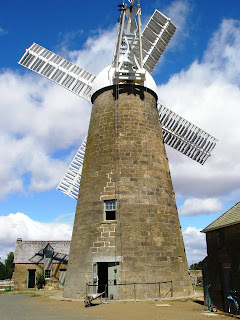
We were lucky that on our first morning, when we entered the local tourist info centre, set up in one of the old flour mill buildings, the girl there asked if we’d like to do a mill tour . . . starting in about 10 minutes.
Of course we agreed, so after donning hair nets and hard hats, and divesting ourselves of all handbags, cameras and phones, we climbed the 58 steps to the top of the mill with our guide, and he then explained its workings as we made our way down, floor by floor.

The Callington Mill at Oatlands. We ended
the tour with scones made from its
flour.

The mill was built in 1837 and operated until nearly the end of that century, but when mainland mills were established, Tasmania no longer could compete in the supply of flour. So it sat idle, was burnt out and was derelict until some years ago when a move was made to reinstate it as a working mill.
The stone shell remained and after a grant allowed a millwright to come from Holland to measure it and manufacture all the machinery needed, as well as the great wooden top and its sails, eventually it was reopened about two years ago and now mills wheat grown in the district.
We spent a lot of time in that wind lurking inside the motorhome, highly amused at the antics of the waterfowl just metres away. In Longford, it had been fornicating ducks that kept the adults amused, and the children somewhat bemused, especially when one drake kept falling off . . . but I digress.
At Oatlands, we saw pairs of black swans doing their elegant neck-arching routine, and even one very puzzled male who simply had his head underwater eating something. When he surfaced, there was a very angry cob right in front of him (“Don’t even look at her, you whippersnapper of a bachelor boy!”) who chased him from the water with much flapping of wings and displaying of tail feathers. And all the while the pen swam serenely around, almost saying, “You’re wonderful, darling”. I’m sure the chased male still has no idea of what he had done to deserve it all.
While the local council maintains some wonderful topiary around the town and by the lake, someone has made steel cutouts of Tasmania tigers, which grace a block of sandstone on the far side of the lake. That’s probably as close as we’ll get to the legendary thylacine, though we did see two fairly motheaten stuffed specimens at the Launceston museum, acquired in the 1800s.

This parking spot, as you can see, is for God's Mistress. The
one to the left of it is for God. We presume that's David
Walsh, founder of MONA, which showcases his esoteric
collection of art.

This fabulous concrete truck is one of the outside
 exhibits,  made entirely of wrought iron pieces.

And so we came to Hobart, fairly early yesterday morning, so we called in at MONA (Museum of Old and New Art), had a wonderful, if almost head-spinning several hours there; then went on to drive up Mt Wellington. That was utterly freezing and we had to reach for our biggest jackets before we ventured out. There was a fabulous view of southern Tasmania, Hobart, its harbour and even the fires on the Tasman Peninsula.
We’re staying at the Hobart Airport Tourist Park, next to the airport hotel, mainly because there’s a shuttle to the city (15 minutes) each morning, returning each afternoon.
We used it today to reach the docks where we took the ferry to MONA, this time to enjoy a long and liquid lunch (John did not have to drive!). There are two big cruise liners in dock, so lots and lots of people at MONA.
Where people went before it opened I don’t know, but apparently it has attracted 600,000 people in 18 months.
Tomorrow we’ll go back into town to go to the Salamanca Markets, followed by a tour of the Cascade Brewery, and on Sunday, as a belated birthday present, John has booked us on a luxury day cruise south along the Derwent with lunch at a place called Peppermint Bay.
To say we’re having a ball is an understatement. We’ll have to suck lemons for a week to take the smiles off our faces.


Tuesday, January 08, 2013

Power to the people


The great pipeline bringing water 900m down
 the mountain to Poatina, deep underground.
 
 
We are back on the road again after a lovely few days at Longford, meeting several new friends, exploring the mountains to the west and the city of Launceston (Lonny to the locals) about 30 minutes away to the north.
And yes, we are quite safe from those disastrous bushfires in the south, though our plan to visit the Tasman Peninsula (Port Arthur etc) has been scrapped for the time being.
Our mountain trip took us in the direction of the great Poatina hydro power station, which itself operates in a cavern in the mountain, but the huge penstock (pipeline) bringing water from the Great Lake in the west, through the mountain, emerges and drops 900 metres to that station, which pumps out 300,000 kW.
As we drove up we could see the great pipeline and were able to get in close to it. To our amusement, there was a sign there saying: Hang Gliding Prohibited. Obviously, the boys had been there, flinging themselves off that section halfway up the mountain.
We kept going after we reached the top and were once again in the highland lakes area, this time on the eastern shore of the Great Lake, where we pulled in to make lunch in the shacks area of Cramps Bay.
Shacks are a deeply held tradition of Tasmanian life. Sometimes I think every second Tasmanian has a shack on the north, west, and south coasts and around the lakes. On the east coast it is a bit more upmarket and they are ‘holiday homes’.
 
This is Johnsy's Jetty on Great Lake.


The lakes shacks are wonderful. They have every known method of generating power, are made from lots of bits and pieces, with sections added over the years and bear names like ‘Pete‘n’Perc’s Shack'. Somehow I think it’s a fairly male domain. When they’re not out in their boats on the lakes trying to catch fish, they’re probably sitting around telling lies about what they caught, or tying their own flies to try to attract the trout.
Anyway, on the way back down the mountain, we called into a lookout to see the headrace tunnel for Poatina (through a locked mesh opening) and look out over the huge farmlands of the midlands, through the prevailing smoke haze from the fires further south.
The next day we drove to Launceston and spent the whole day visiting the two sites of the Queen Victoria Museum and Art Gallery. The wonderful thing about Tasmania is that nobody ever seems to throw anything away and people have collected stuff from the colonial era, then donated it to the museum for people like us to enjoy.
The history of the place is wonderful, well-preserved, and presented so well for visitors to see.

When we left Longford this morning we set our sights on the heritage villages along the Midland Highway, Campbell Town, Ross and Oatlands. At the same time the weather had changed from hot, clear days, to overcast with strong winds and by the time we reached Oatlands it was threatening rain, and I swear the temperature had dropped about eight degrees.
Once again, wonderful history preserved in Campbell Town and Ross (we’ll check out Oatlands tomorrow). We travelled from Longford along some back roads, rather than the highway and at times one could have been driving through the Darling Downs or even western Queensland.
 
Is this really Tasmania? It's the fertile but dry midlands.

Wheat harvesting is in full swing, there were sheep and cattle everywhere, fairly dry plains all around and the poppies will be harvested soon. Tasmania produces half the world’s requirements of medicinal opiates, e.g. morphine and codeine. There were lots of green fields of poppies in the north, some flowering their pink-tinged white, but in the midlands, obviously the flowering is over and the pods seem ready to be harvested. There are signs on the fences around these crops warning of death if the plants are stolen and ingested.
We had not realized how much wheat was grown in Tasmania, along with onions and potatoes (with supermarkets and greengrocers sporting potato sections with up to eight varieties) as well as all the glorious cherries, apricots and raspberries.
We are camped beside Lake Dulverton at Oatlands, just metres from the shoreline, with black swans, coots and even seagulls all milling around on the water’s edge. After days of heat, this afternoon it’s so cold we’re reaching for jackets, and may well start wearing the thick woollen socks we bought at the Tasmanian Wool Centre at Ross today. Brrr!

Saturday, January 05, 2013

Heat and fires

At last . . . relief from the heat!
I write this in a lovely caravan park at historic Longford, just south of Launceston, our home for the next 2 nights on the grassy banks of the Macquarie River.
Unfortunately there seems to be something odd about the blogging website tonight and I can't seem to insert any pix. So you'll just have to put up with some pen pictures instead.
We arrived today after several days on the east coast, mostly out of mobile phone coverage, so we could send and receive text messages (sort of) but could not make calls or access the internet.
After we left Triabunna we headed north to Coles Bay and the Freycinet National Park. Glorious! The place was seething with people and we fully expected we would not find a parking spot in the carpark from where one sets out on the national park walks.
But the Nat Parks person supervising the parking took one look at our rig and directed us to the area for tour buses. Then we walked to the Wineglass Bay lookout (about 2 hours) and quite steep in places, although well laid-out with lots of stone steps.
I had done that walk when in Tasmania in 1995 for Nigel’s wedding and remembered it as much more rugged. Aha! The way down was in fact mostly that old track, and our knees certainly told us all about it that night.
We were cruising the beaches north of Coles Bay when we decided to stop for lunch at one of the Friendly Beaches free camping areas. Most of these little niches among the heath were already occupied but a largish one near the toilets (pit, with a rather nifty flushing pump handle thingy) had just a young couple putting up a tent.
We decided to stay . . . and by nightfall were surrounded by tents, other campervans, and even people sleeping in cars.
Although a glorious beach, it was very windy and we knew the next day was going to be very hot . . . and we were fed up with the fine blackish sand around the vehicles . . . so we headed north the next morning, finding some lovely salmon fillets from a fish shop on the wharf at Bicheno.
This nice little town was in mourning for a popular GP who had died on Christmas Eve and several shops had signs announcing they would be closed for his funeral service.
After buying some rather special bits and pieces in the post office, which also doubles as a small gallery for local card makers, leather workers and jewellers, we pushed on further north to Scamander where we found a caravan park close to the ocean. On the way we saw fire up in the hills and heard on the radio that night that fires were threatening places in the east and south.
I will never forget my birthday, the next day, as that was Tasmania’s hottest for decades. It reached around 39C in Scamander, with a howling westerly wind to boot, so we just retreated inside and cranked up the air-conditioning for the first time. It was a totally lazy day, as we spent it sleeping, lying around, reading and doing a large crossword in the Age newspaper. A letter in that paper that day had queried how many people were able to do the daily summer crossword without resorting to Google, dictionaries, a thesaurus, or some other internet search engine.
Well, we did! Mainly because we could not access any of those things anyway.
It was a huge relief when the sun finally went down . . . it’s still twilight here about 9pm . . . and the air cooled slightly. But of course, the evening news was full of the disaster that the Tasman Peninsula had become, and we heard that campers at Friendly Beaches south of Bicheno were being evacuated because of a fire risk. How glad we were that we had left that morning!
The wind changed during the night and we awoke today to find it so cool we needed long sleeves to start the day, and the air was full of smoke. As we left the east coast and headed inland, we drove away from that smoke into the dry, dry midlands, full of sheep and wheat.
We explored the pretty little town of Evandale,  then went west to Longford, which is delightful, and decided to stay. This afternoon we went just out of town to the historic Woolmers estate, in the Archer family for 180 years until the last owner died without issue in 1994 and it passed to a foundation which runs it now. The homestead and buildings still contained everything the family had acquired over the years, including furniture and china from England and a whole section had been added in 1840, just for entertaining.
It is also the site of the National Rose Garden, which was showing the effects of that extraordinarily hot day yesterday. We thoroughly enjoyed our afternoon there but it was a really warm afternoon so we were pleased to return to our riverside site, where people were canoeing and fishing, and like us, sitting in the shade having pre-dinner drinks.
In a complete turnaround of weather, so typical of Tasmania, the wind cooled a lot in the early evening and we found ourselves reaching for jackets again.
Tomorrow is forecast to reach 27C so it should be a lovely day for exploring this pretty little town, and maybe the mountains nearby.

Tuesday, January 01, 2013

Walking through more history

And a Happy New Year to everyone!
We are tucked up in a dear little caravan park at Triabunna, on the east coast of Tasmania, on a cloudy, rainy, sometimes sunny, but always windy January 1, 2013.

The 2011 carving outside the 1846 church.

Before we left Buckland, just a little way inland, we visited its famous little Anglican church. It’s famous because of its wonderful east window, which is believed to have been  made between 1350 and 1400 for Battle Abbey, built in Sussex, England, by William the Conqueror. When the abbey was torn down by Cromwell’s men, it is believed the window was buried for safety, later being sent to the first rector of St John the Baptist Church in Buckland (1846-48) by aristocratic friends, the Cecil family, in whose care it had been for hundreds of years.
The amazing thing is that the little church is not used much these days, but is open for visitors at all times, with a movement sensor light that comes on once one enters by the great wooden door; and there is a light on a time switch in the chancel to better illuminate the famous window.
And there’s no vandalism!
In the churchyard, as well as lots of graves dating from the 1800s, is a 2011 chainsaw sculpture of St John the Baptist being baptized by Jesus. It seems a bit incongruous but it is by the Tasmanian master of that kind of art, Eddie Freeman, whose work we saw at Legerwood.
Then on we came to Triabunna, making it our base for a few days, particularly while we explored Maria Island, an hour away by a small ferry. It was just an hour across a glassy bay to get there, but the wind and waves came up while we were there (10.30am to 4.30pm) and the return trip was very rough.

Cape Barren geese are everywhere on the island.

Maria Island is a fascinating place, having had two lots of convict use, then an Italian entrepreneur leased it late in the 1800s and started growing wine grapes and mulberry trees to make silk, built a hotel and a coffee palace, and even advertised the island as ‘Australia’s Riviera’, enticing people to come to visit. His enterprises eventually failed, and the Great Portland Cement Company built quite a big industrial centre there, with 500 workers, but it also failed at the Great Depression.

Some of the happy 'campers' in the penitentiary.

A few people kept farming there but by 1972 it had become a national park. People can camp there, or stay in the bunk-bed penitentiary. They have to take everything they need. .  and they do! . . . and can take bikes or hire them from the ferry operators.
We just went for the day and walked our little legs off. There are several great walks, some in the bush, and others around the clifftops and across open grasslands so we combined a couple to walk for about 4 hours, having our picnic lunch overlooking a dam built by the convicts in the 1800s to supply the settlement, Darlington, with water. It is still used.
Most of the convict buildings are still there, with interesting history boards sharing the stories and the remains of Diego Bernacchi’s enterprises are also still visible, as are the huge cement silos.
We had a nice little New Year’s Eve celebration with some people camped near us, including a Gold Coast couple who used to live in Kyogle, there were a few fireworks let off and a couple of yells at midnight, but otherwise Triabunna, a mussel, abalone and scallop fishing centre, remained fairly serene.