Monday, August 29, 2016

Monks, food fests and wavy rocks


The chapel in the former boys' boarding
school.
New Norcia. What a sublime place. I can see why my friend Maureen R. loves to visit it from Perth as we spent two glorious days there, ate several times at the gracious hotel and enjoyed an extensive guided tour, particularly into places not usually seen by people just wandering around.

The history of the place is wonderful and we loved prowling around the museum which shows just how hard those early monks worked when it was first established as a mission in the 1840s. The buildings are wonderful, particularly the former boarding colleges for girls and boys, with glorious, almost Renaissance-style chapels.

Even the hotel, gracious and with a Gone With The Wind staircase, was built as a hostel for the visiting parents of the boarding school students. It serves interesting meals, is
The lovely hotel at New Norcia.
obviously the local watering hole for the farm families around, and we sampled the Abbey ale and wines bearing the New Norcia imprint.

While there we saw a poster at the visitors’ centre advertising the Taste of Chittering. So when we had found Chittering on the map just a bit south of New Norcia, and then discovered Toodyay (pronounced Two-jay) had a lovely little bushland caravan park, we had an enormous journey of about 98km from New Norcia. The caravan park was a joy, set outside Toodyay, with ringneck parrots everywhere, ducks on a couple of dams, a tame peacock called Henry, and a couple of emus kept behind a high fence.

Toodyay is a prosperous, historic town set in the wheatbelt, very pretty, and a short drive through bushland and farmland from the Lower Chittering Hall where the food fest was held on our second day there. It was delightful, not nearly as big as the one we attended in Felton, south of Toowoomba, in April. We found local honey, jams, asparagus, bakery goods, coffees and even paella for lunch. There was a stall covered in wildflowers from one of the local commercial plantations, which sells its flowers direct to Holland and Japan, and even our guide from New Norcia turned up with a colleague as they manned a stall with the New Norcia wines, oils, breads and cakes.

After that, we actually headed east for a while to Wave Rock, just outside a little town called Hyden. We arrived in the early afternoon, so climbed the rock (helped by a few stairs and a chain which one can use to help make the ascent). It wasn’t difficult and the surprise was that, apart from the famous ‘wave’ in the rock, caused by millions of years of water action, there is a dam formed by part of the rock and a dam wall built in 1928 so that the town would have water.


To get here we drove through several wheatbelt towns, all very old, and our favourite probably was York, settled in the 1830s and still full of some glorious old buildings. No centres are very far apart now that we’ve in southern WA. It is very different from the hundreds of kilometres we’ve had to travel in the real Outback just to reach the next town.

Tomorrow we head south, aiming to reach Denmark and then Albany, sometime in the next few days. That will make it nine weeks on the road, and almost 14,000km since we left home.

Sorry . . .Having computer/internet access troubles and can't upload any more pix.
Next post: The South Coast of WA

Wednesday, August 24, 2016

From princes to wreaths


We’ve been from the sublime delights of Kalbarri to the somewhat eccentric, and rather dilapidated, surroundings of the Principality of Hutt River.

Many of us will remember the wheat farmer, Leonard Casley, seceding from Australia over what he considered unfair wheat quotas in 1970. At first he called his land the province of Hutt River, but later made it a principality, and he termed himself HRH Prince Leonard and his wife was HRH Princess Shirley. We’d heard about it, and as it had celebrated its 46th anniversary this year, and is supposed to be a tourist drawcard, decided we’d visit, particularly as it has recently opened a campground.

A sculpture of HRH Prince Leonard near the entrance
to the Principality of Hutt River.
So south we drove from Kalbarri, first having a wonderful visit to the Rainbow Jungle, which specialises in parrots from Australia and overseas. Not very long after that we were in rolling wheat fields. When we entered the 75sq km that is the principality, there was no great fanfare or massive gateway, just an entrance from a dirt road, with welcoming words on a stone fence. The township established there is called Nain, and has what are called the government offices and post office (a simple brick building); a chapel which has become a sort of shrine to Princess Shirley; what is termed a tea-room but it now just has a DIY urn, plus a mementoes room; as well as an educational shrine to Shirley which contains not only some Chinese figures and writings (from Leonard’s great friend Martin Louey) but also Leonard’s mathematical formulae for what he calls the ‘spirit code’ which allows him to assign a number value to every living thing. He has also devised his own Fibonacci series.

It was all a bit tired looking, with several clapped-out caravans, vehicles and farm machinery cast aside near buildings that didn’t seem to be used any more. Graeme, the youngest of the couple’s four sons (there’re also 3 daughters married and living in Perth), mans the post office, stamping visas, putting Principality of Hutt River (PHR) stamps in passports . . . John has his with him, mine is still at home . . .selling their special stamps and generally providing info. We could see his father sitting in a chair in the tea-room, talking to other visitors but by the time we got there, after settling in the campground, he had obviously gone to a 90-year-old’s afternoon nap in the modest little house nearby that he shares with Graeme.

Prince Graeme told us the other brothers look after the farming side of the enterprise, and with the eldest almost 70, they are all hoping to retire and that some of the grandchildren will take over. But whether they want to keep growing wheat, lupins, and dorper-damara cross meat sheep . . . and reinvigorate the tourist side of the business . . . is another matter.

One suspects the other brothers might keep their distance from the HQ of the principality, as they have homesteads in far-flung parts of the property. It will be interesting to see what happens when Leonard dies, despite Graeme’s optimistic assertion that there was a succession plan in place.

It was beautifully peaceful in the campground, with only about 6 other travelling rigs there. The next
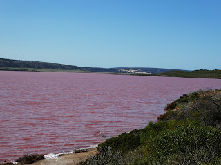
The lake really is pink.
morning we drove on south through this northern part of the WA wheatbelt, and on the coast came to the extraordinary Pink Lake. This is coloured by some microalgae that is actually harvested for food colouring and Vitamin A.

Fairly soon we came to Geraldton, where John had to collect a new tail light he’d ordered; but we avoided the CBD and headed south to Dongara where we managed to get a spot in a lovely little caravan park. It has a lot of cabins and permanent residents, but its sites each have an en suite bathroom. There was a surprise when we opened the door, as not only did it have a spacious shower, and separate toilet, but also a washing machine!

When we sought advice from the local visitors’ centre, we were issued with a wildflower kit with info and maps and one of the employees assured us she’d made a run east into wildflower country only the weekend before so gave us great advice.

Beside a pathway in the conservation park.
The next morning we set off for an eight-hour journey among small towns in the wheatbelt, just about overdosing on wildflowers. The landscape was impressive . . . green wheat to the horizon in all directions; contrasted often with great paddocks of yellow-flowering canola. On the side of the roads and edges of the cultivations, wildflowers were growing, and some fallow fields also were bright yellow at ground level with wildflowers.

We went through the Coalseam Conservation Park, where coal was first mined in WA and where one can still see it exposed, and it was  knee-deep in yellow pompom everlastings.

Further north we followed directions to a tiny village of Pindar, and then a dirt road for 10km to see the famous wreath flowers. These grow in the shape of a wreath in the sandy soil beside the road, and are so famous that there were cars and caravans pulled up everywhere with people trying to capture the spectacle on camera.

By the time we returned to Dongara we had driven a round trip of around 400km, been through several small towns; helped the economy of one by spending up big at the bakery; and then just outside Dongara we called to see the son of one of John’s friends back east. John and Danny had last seen each other in 2006.

Next post: Further south to New Norcia.

Sunday, August 21, 2016

From jetty tram to Apollo space flight


We returned to Carnarvon after our few days in the bush, once again glad to see its green landscape and ready to explore it. A ‘must’ was the Coffee Pot tram that takes visitors out along the mile-long jetty that has been there since the late 1800s.

The driver, a glorious little lady called Sas, who told us she and her twin sister were among 23 in their family, takes the little tram with its two passenger cars almost to the end of the jetty, waits until her passengers have explored as far as they can go (there’s a barrier stopping access to the very end as there are several unsafe pylons) then trundles everyone back to shore. We lunched at the restaurant there, then discovered its historical display, including one of the lifeboats from the Kormoran, which had come ashore nearby after its battle with HMAS Sydney II in WWII. Both ships went down, along with the Sydney’s entire 645 personnel. There was an interesting film we saw, dealing with the search for the Sydney in 2008, its discovery, and the fact that its bow came off as it tried to limp away from the battle scene, sending it straight down with no chance of anyone surviving.

The next day we went north of Carnarvon to the Quobba blowholes, camping area, memorial to HMAS Sydney II and pastoral station. One blowhole in particular was really ‘working’ when we were there; we put some wildflowers on the Sydney memorial; checked out the camping sites among the most glorious fishing shacks made of whatever was to hand; and visited Quobba station.

The view of the space museum and dishes from our
caravan park. Disregard the two smaller dishes.
They are for the NBN.
When we returned to town, we completed an interesting day by visiting the Space Museum. This has been established on the site of the old space tracking station which took part in many NASA space missions, including the Apollo Eleven moon landing. A highlight was being able to spend time in a replica Apollo capsule, lying down, legs elevated, lights flashing, rockets roaring as we experienced lift-off and the view of Earth from space.

From high technology we went back to the 1800s again when we left Carnarvon and travelled south to Shark Bay, staying at Hamelin Pool. The campground features one of the old overland telegraph stations and campers can do a tour each night, where they not only learn about the old telegraph line to Broome but also the stromatolites (rocky growths) which are a feature of that hypersaline sea. The pool is part of Shark Bay but seagrass and sand have formed a barrier which keeps it super-saline, perfect for the primitive little organisms that build the stromatolites. They are supposed to be the first oxygen-producing things on earth so are billions of years old.

The bright white of Shell Beach, Shark Bay, literally
made of tiny shells. At the end of the beach is a 'shell
mine', making shell grit for Australia's budgies.
One day while there we drove on into the World Heritage area of Shark Bay, visiting the small (windy) town of Denham and Monkey Mia, where people go to feed dolphins each morning. It was after midday when we arrived there and we hadn’t really been interested in feeding the dolphins, just intending to have lunch at the resort. We laughed when we saw a couple of dolphins only about 30cm from the shoreline, obviously a bit late, but hoping there might be something for them. Each was attended by a pelican hoping that if some fish was on the menu for the dolphin, then he might be able to get to it first. But there was no more feeding, so all four were disappointed.
The tiny shells from dead Fragum cockles that make up the beach.

That afternoon the campground was pretty busy, particularly when in chugged four tractors towing caravans, as well as some supporters in 4WDs and vans. It was a Chamberlain tractor club from WA, though they do have some eastern Australian members, and they are having their annual expedition.
This one, lasting most of August, is within WA but in previous years they have travelled up Cape York, the Canning Stock Route, to Birdsville and even to Byron Bay. We had a good old chat to one of the drivers and we laughed when later we saw some of the tractor party having a hard look at a rather derelict tractor beside a shed at the campground, taking photos and no doubt working out how to restore it.

Wildflower update: The drifts of colour have become carpets either side of the road, and as well as ground covers, the bushes and shrubs are also bursting into flower, with lots of wattle in various shades of yellow, as well as red, pink and white-flowering plants.
We then gave ourselves three days to just veg out in Kalbarri, a pretty coastal town at the mouth of the Murchison River, eating out, reading, walking, and not bothering to look at maps or plot our next movements.

Next post: Kalbarri to Geraldton, including the Principality of Hutt River (all hail Prince Leonard of Hutt who seceded from Australia 46 years ago!).


Tuesday, August 16, 2016

Wildflower drifts and burrowing bees


We reached Exmouth just in time for the Census, with someone delivering a form to us in the caravan park. We decided to fill it in and post it, rather than do it online, which was lucky, considering what happened to the website.

Anyway, we enjoyed our time there, spending the best part of a day exploring the western side of the cape, which is Ningaloo World Heritage area. The sea was the most glorious turquoise, the sand was white . . . but a screamingly cold southerly was blowing so we didn’t venture into the water.

When we drove south to Carnarvon, we found that some of the tentative bursts of wildflower colour we’d been seeing for weeks had intensified into drifts of white, yellow, mauve, acid pink and even deep purple under the shrubby bush growth. These were tiny individual plants and looked like groundcovers, and there are also larger bushes laden with pink or purple blooms, blue or yellow as well.

But the real surprise on coming close to Carnarvon was the sight of plantations of bananas, mangoes, tomatoes and zucchini. It was such a joy to see green growing plants after weeks of pretty arid countryside, even though the recent rains have brought on short grass and the wildflowers.

We had just one night in town, then headed east to Mt Augustus, a monolith or inselberg (island mountain) that rears out of a fairly arid plain around 400km north-east of Carnarvon. The first 180km were on bitumen, to the tiny town of Gascoyne Junction, then we just went about 60km on a dirt road to spend a night at Kennedy Range National Park.

It was absolutely glorious! The little campground nestles in under part of a wonderful rocky range that is 75km long and 25km deep in places, full of great walks in the gorges. We did one the afternoon we arrived, then awoke at the crack of dawn, packed up and drove a short distance away
Heading up Temple Gorge, so-called
because of the large rock slightly
like a Mayan temple.
to another part of the park where we did a short walk to what is called Honeycomb Gorge, so called because a natural waterfall and general weathering has created a honeycombed effect on the cliff face.

Then we drove for 260km on relatively decent dirt roads to reach Mt Augustus National Park and a pretty little campground, where caravans, campervans, camper trailers and motorhomes ring a sort of village green (“No wheels on the grass!”, said the woman in the office). Great flocks of corellas and galahs made a soaring, raucous farewell to the day, then settled in trees well away, thank goodness. On our way there, driving through endless arid vistas, John remarked, “We’re in a great heap of nothingness, in the middle of bugger all”. That said it all.

Bright and early the next morning we set off to drive around the great rock that is Mt Augustus, stopping every so often to do short walks into gorges, climbing a little way to the top. We didn’t do the 8-9 hour walks which would have taken us to the summit . . . too much respect for our ageing knees. But we thoroughly enjoyed what we did, which often were not so much walks as
Mt Augustus
scrambles along rocky gullies, so our hiking sticks were well used. These walks brought us close to the extraordinary variety of flowering bushes that are starting to come to life on the rocky mountainside.

A highlight of the morning was finding a whole group of burrowing bees on the road. They had been noticed by the National Parks volunteers in the camp the day before and they’d marked the spot with witches’ hats and rope so vehicles would not drive over the bees as they burrowed deep into the clay, making little chambers where they placed pollen and nectar, laying one egg in each. When these
The extraordinary 'burrows' of the bees.
The stingless native burrowing
bees are among the largest in
Australia.

females have completed their task, and had several eggs safely tucked away, they come to the surface, filling in behind them, and usually then drop dead of exhaustion. The eggs hatch into pupae, which consume the nectar and pollen, then nod off for about a year, during which they transform into the next generation of bees which come to the surface, are fertilised by the waiting males . . . and on the story goes. These are some of the biggest native bees in Australia, only found on the northern plains of WA.

One of the 'easy' walks at Mt Augustus.
By midday, when it was almost too hot to do any more walks, we went to the last spot on our map, a large permanent waterhole on the Lyons River, which runs behind the campground. There we had lunch, contemplated a swim, but ended coming back to camp, adding our sweaty walking clothes to a pile of washing, which then dried in the afternoon sun.

On our way back to Carnarvon we stayed at Gascoyne Junction, a tiny town almost wiped out by the flooded Gascoyne River in 2010. Since then the local council had obtained a Royalties for Regions grant (one of the best things the WA Govt has ever done, in that we’ve seen so many great projects funded by those mining royalties).

The 100-year-old pub close to the river was destroyed in the flood, so for the past two years there has been what is called a ‘tourist precinct’ . . . a brand new service station/café/bar/restaurant with a caravan park attached featuring cabins, a pool, and a flock of backpackers, including a French chef, who staff the roadhouse. Naturally, we ate at the restaurant that night, had a great time with a couple travelling from Bundaberg, and then set off the next morning to return to Carnarvon for a few days.

Next post: Carnarvon, then Shark Bay.


Monday, August 08, 2016

Natural gas and Red Dog


Aug 2 – 7

What a great time we had in Karratha. It’s quite a large city these days, once again, part of the whole mining and natural gas enterprises of the north-west of Australia, so we were able to find some of the technical services we needed.

My mobile phone had suddenly lost its capacity to turn on wi-fi; John’s camera seemed stuck in closed mode; we needed some new chairs as one of our relatively cheap ones had a broken arm and ended up in a bin; and we definitely needed some food, wine and beer.

As well as getting those essential supplies, as well as advice that maybe the devices had partially gone to God . . . we drove north on the Burrup Peninsula to see the mighty north-west shelf gas
The North West Shelf Gas project near Dampier.
project. It is truly astounding and once again we marvelled at man’s ability to engineer all these marvels. We thoroughly enjoyed our day on the peninsula, with lunch at Dampier, which has a lovely small harbour for small craft, and there’s a café on a hill looking down on it where we had great fish burgers.

We met a Tasmanian couple in the campground who knew people we know at Lennox Head . . . what a small world it is indeed.

The next night, happily in a waterfront site at Onslow, a neighbour stopped to chat and when he found out we lived in Lismore, announced he had dear friends at Alstonville, people he had known from New Guinea days when they had plantations on Bougainville . . . and of course, I knew them as well. We had a great old chat the next evening when we joined them for drinks.
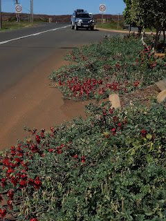
The memorial to the real Red Dog, on Dampier's outskirts, erected by his many friends in 1976; and Sturt's Desert Pea spilling onto the roadway at that information bay.


On our way to Onslow, home of huge salt evaporation ponds, as well as a monstrous new gas plant under construction, we had visited the site of Old Onslow, to the south, near the mouth of the Ashburton River. It’s a popular camping area along the river, and the council ranger who knocked on the door while we had stopped for lunch beside it, told us there were about 35 caravans, motorhomes or campervans there at present, but a week or so ago there were 65. A little way away, but looming on the horizon, was another natural gas plant under construction, Wheatstone.

The river was lovely and I waded across it on a causeway to take photos of John driving the truck
Across  the Ashburton River.
across. Pelicans were perched on a weir upstream, which was built to keep the salt water from the Indian Ocean separate from the fresh when people lived at Old Onslow. Eventually the river entrance became too difficult to navigate to export wool and livestock and the whole town was moved further north to its present position . . . but there’s no wool going out now, just salt.

We were headed south to Exmouth but it’s a very popular spot and we could only get a booking at a caravan park in a few days so we decided to leave Onslow, where the sandflies were biting hard, even though we really enjoyed our beachfront site there; the great boardwalk along the coast; and the refurbished old pub where we had a great meal out. We had three days to reach Exmouth so the first day only went about 200km south on the highway as far as Barradale, a very popular campground on a river.

We’ve been amazed at the great roadside campgrounds established by WA Main Roads, each with a dump point for caravan/motorhome toilet cassettes. That one even has the extra attraction of the Burger Bus, run by Joyce Penny from a station 20km away.

She told us it only started in February this year, after taking 18 months to get all the necessary permissions. She drives there to start at 7am and leaves at 3pm. We had coffee with her when we arrived in late morning, found a nice little nook in a grassy spot near the river, watched as about 50 to 60 other caravans, motorhomes, camper-trailers and campervans pulled in during the day, each finding a nice spot, then we had bacon and egg toasted sandwiches and coffee with her for breakfast the next morning. While she gets quite a bit of business from people in the campground, it is the truckies on the highway who are her main clientele.
Joyce at the servery on her Burger Bus.

Joyce and her husband Darryl run Emu Creek station, which they also operate as a tourism business, and because Joyce is the Burger Bus maestro, Darryl looks after the campers on the station, as well as the station work. Joyce joins in when she returns from the highway each afternoon, and also does all the bookwork. They are hoping to sell the station and its 1200 cattle, but in the meantime, they battle on.

So on we drove, only about 100 km to a delightful cattle station called Bullara which has camping sites, some powered, as well as rooms in the old shearers’ quarters, coffee and scones on the veranda of the homestead and damper around a campfire every afternoon.

Next post: Exmouth to Mt Augustus


Tuesday, August 02, 2016

Gorges, iron ore and leviathons of the sea


July 30

What a wonderful few days we’ve had, camping in Karijini National Park, walking, driving, marvelling at its wondrous gorges and pools and meeting other campers from all over the world. The gorges suddenly appear in a landscape of undulating, spinifex-covered hills and low scrubby vegetation.

And what gorges they are. People had told us that the
Spot the walkers at the base of this gorge.
Pilbara was much more spectacular than the Kimberley . . . and we were pretty impressed by it . . . and they were quite right.

Our one regret was that with only two good knees between the two of us, we didn’t go leaping down the rocky paths to the pools in the gorges. If we’d been 30 years younger (and with knees in better nick) we would have joined all the young people making it to the gorges and splashing in the pools.

As it was, we did a lot of rim walking and visited all the major places of interest in this very large national park. It doesn’t take bookings, so we were very lucky to have arrived around 2pm on the first day, and there was still one vacancy . . . just for us! Every day, the volunteers helping the ranger with this task of booking in campers put out the Campground Full sign around then, with people told to go to an overflow area and come back early the next day.

This they did every day, with about 20 motorhomes, caravans, camper-trailers and vehicles with tents waiting when we finally left one morning around 8.30am after 3 nights there.

The reason we were so late arriving from Newman, about 200km away, was that just as we were about to leave that mining centre, we discovered there was a mine tour we could do . . . so along with about 20 other people, we were
Inside a loading scoop above the Newman
open cut mine.
equipped with hard hats, safety glasses and high-vis vests before piling into a bus and going out to the BHP Billiton Mt whaleback site.

It was fascinating, looking down into the enormous open-cut pit (around 5km x 2km) and hearing about the operations going on down there. A couple of the 2km long iron ore trains that travel from Newman to Port Hedland were in while we were there and we heard all about their loading procedures and their operations, with just one train driver in one of the lead locos, and the two locos in the middle of this huge train controlled remotely by him.

We were thrilled to find that when we left Karijini and got back on the Great Northern Highway, heading for Port Hedland, we drove through a wonderfully wide gorge called Munjima. It was a majestic experience.

We stopped before that mining port town to spend the night at Indee station. It’s a cattle station that has welcomed guests for some time and the highlight of each day is Happy Hour at the homestead with the owners. There were geese pottering about and a group of poddy calves who wandered around welcoming pats from the campers, mostly in caravans.

So on we went to Port Hedland, staying at a caravan park with one side facing the beach and the other, where we had a site, looking down at a mangrove creek and across some waste land to the enormous port operations. At night, when all the lights were on, it was a veritable industrial city.

On our way into the town we had paused at a road overpass where one can look down at the enormous ore trains
rumbling in day and night from the mines. It’s also a good place to view the salt operations by one of Rio Tinto’s companies. Salt is evaporated in a series of enormous ponds, then pushed into a huge pile, from which a loader takes great scoops to load three-trailer trucks heading for the port.

We saw one of the huge bulk carriers being shepherded into the harbour channel, and later discovered we could do a launch tour of the ships in the harbour, run by the Seafarers Centre, which looks after the sailors coming ashore for a few hours.

Ready for a few hours ashore.
So on August 1 we went from ship to ship (among the 14 or so berthed for loading), letting off some Russian men at one, laden with shopping including a case of beer, and taking on lots of Chinese and Filipinos at other ships. Most of these huge vessels only have 20-25 crew and the Seafarers Centre helps them with any problems, changes their money (usually US dollars) and takes them to the local shopping centre.

It was a fascinating hour or so on the water and we enjoyed seeing the huge port facilities from that perspective. The majority of ships were being loaded for BHP Billiton, with some for Gina Rinehart and others for Fortescue (Twiggy Forrest). We counted up to 13 bulk carriers standing well offshore, waiting for their turn at the loading berths . . . and still the ore trains rumbled on in, bringing more riches to the port.

Next stop for a couple of days: Karratha.